
- GeoData
- » Gis
| Date: | 1996 |
|---|---|
| Project: | uc9991 |
| Client: | Federal Environment Agency - UAE |
| Associates: | EMU Ltd |
Environmental Sensitivity Index mapping - United Arab Emirates
GeoData working with EMU Ltd developed an approach to environmental sensitivity index mapping for the United Arab Emirate coastline.
GeoData developed the physical coastline classification, and undertook data analysis in databases to build the data into the Geographic Information System.
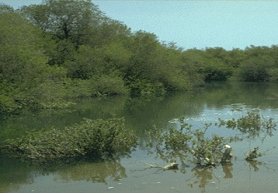
The system was developed using SPANS and MapInfo GIS to integrate the ecological data with the physical shoreline classification. The Environmental Sensitivity Index (ESI) was mapped at 1:50,000 scale and presented as colour maps accompanied by a CD-ROM-based photo archive of typical shoreline sensitivity classes.
Major challenges of the lack of current mapping at a reasonable scale were overcome by utilising recently acquired satellite images. Processing to geo-correct to the two UTM zones within the UAE was used to derive basemaps for map update and presentation purposes.
GIS training on MapInfo was conducted in UAE. Subsequent commissions have mapped biotopes within the areas of Al Taweelah and Al Dabbiayah as part of Environmental Assessments for marine industry development.