
- GeoData
- » Geomorphology
| Date: | 2006 |
|---|---|
| Project: | uc0928 |
| Client: | University of Southampton |
Geomorphological mapping of New Forest streams
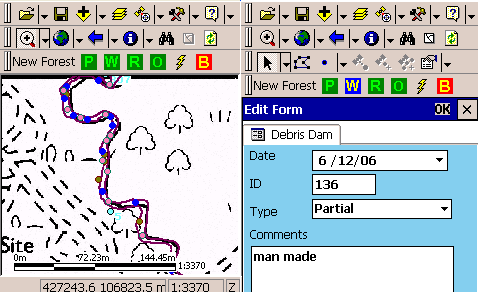
An ArcPad 6 application was developed for the School of Geography to aid spatial data capture of geomorphological features along streams within the New Forest, UK.
A custom tool bar and data capture forms were created for capturing features along two New Forest streams. The application allowed the fieldworker to capture the location and type of debris dams, pools, riffles and photo IDs. Photographs from a previous survey were included as a point layer and hotlinked to jpeg files stored on an SD memory card. This allowed the fieldworker to make in field comparisons. Data brought back to the office at the end of each day was synchronised with the desktop GIS and immediately available for analysis.