
- GeoData
- » Training
Mapping Historic Overland Trade Routes from Southampton Docks
GeoData recently provided GIS and database training to Winifred Harwood (University of Winchester) who is working on research project to analyse historic inland trade from Southampton docks, during the middle ages.
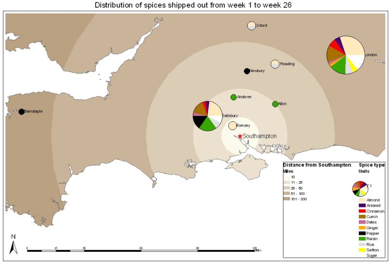
A number of inland trade brokage books, written in the middle ages, in Latin, have survived and have subsequently been edited and published in the Southampton Record Series, housed at the Southampton Record Office. The records (unique to Southampton) offer a fascinating glimpse of inland trade over 500 years ago, specifically, daily records of the commodities which entered or left Southampton, by road, through The Bargate.
The books record tolls paid on goods as they entered or left the city for destinations elsewhere in Hampshire and counties further afield. They also show the destination of the goods, their ownership, and the name of the carters carrying them.
GeoData took the existing Inland Trade Brokage Project database (holding records for a six month period between 1447-1448) and provided some enhancements including spatially enabling it for use in ArcGIS. Maps and statistics were created for the ranges of goods (e.g. wine, wool etc.), together with the quantities of goods being shipped to the various cities and towns.
The work formed a proof of concept for a much more ambitious 5 year project which has been planned to look at selected brokage records and to analyse and map records between 1439-1540.
It is hoped that the work will increase historians understanding, not only of Southamptons commercial networks, but also of those of Hampshire and all those English localities that traded with Southampton.
Download project presentation (PDF).