
GeoData provides integrated data and information services for a sustainable environment and society
GeoData's approach has been founded upon a commitment to integrated, multi-disciplinary projects emphasising science and survey with a strong basis in environmental and socio-environmental data handling and access.
We work collaboratively across the multiple disciplines of the University and with national and international partners to deliver data, information and applications to support decision making.
Latest News
Posted 2026-07-03 10:44:54 by Admin
OS festival 2026

What a brilliant day at the Innovation Festival in Ordnance Survey. Not even a record-breaking heatwave could keep the #geospatial community away, and the energy in the room was genuinely infectious. ...
Posted 2026-07-03 10:46:32 by Admin
Geobusiness 2026

On the 3rd and 4th of June, GeoData Institute had the chance to be represented at GeoBusiness through Southampton Geospatial. Visitors had the opportunity to speak with two of our colleagues, Chris Em...
Posted 2026-07-03 10:46:58 by Admin
GeoData present in Southampton Geospatial Summer School

From the 13th to the 17th of July, the University of Southampton will host the Geospatial Summer School. As part of the programme, GeoData Institute will contribute on Tuesday, the 14th of July, with ...
Recent Projects
Posted 2025-05-23 11:16:07 by Duncan Hornby
Open Rivers Network
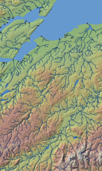
The Open Rivers Network is free dataset released under the Open Government Licence v3.0. It is built upon a 2023 release of the Ordnance Survey Open Rivers dataset. The Open Rivers Network contains ov...
Posted 2025-05-23 11:33:32 by Admin
Woodland Impacts of Development: Guidance, Evidence and Tools (WIDGET)
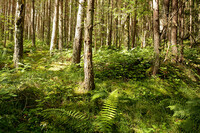
GeoData has led the technical team contributing evaluation and recommendations to the Forestry Commission on Evidence, Guidance and Tools. This multidisciplinary project was funded under Government’...
Posted 2025-05-23 12:46:46 by Admin
National Coastal Monitoring Programme
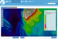
GeoData are responsible for all aspects of the National Coastal Monitoring Programme data management and open data web portal, including geospatial database and metadata search engine, web-based GIS i...


