Stories tagged with "Data visualisation"
Posted 2025-11-18 17:24:33 by Andrew Campbell-Sutton
Cultural Strategies Explorer
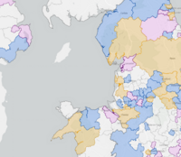
GeoData created a web map that displays information about cultural strategies at various Local Government levels in the United Kingdom. The map is part of an accessible Think Kit resource pack desig...
Posted 2025-05-27 10:49:50 by Admin
Medieval French Roads
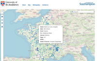
The Medieval French Roads Project offers a digital, interactive map showcasing roads and bridges in France from the 11th to the 16th centuries. This resource is built upon primary sources such as hist...
Posted 2025-05-27 10:47:49 by Admin
Peter Cook Postcards
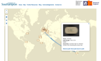
The Peter Cook Postcards project provides digital access to a collection of postcards from the Hartley Library at the University of Southampton. Around 100 postcards depicting Southampton's history as...
Posted 2025-05-23 12:42:51 by Admin
Atlas of Birth
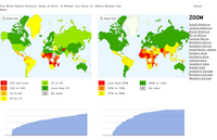
A tool to generate customised charts and maps illustrating maternal health around the world. The White Ribbon Alliance is an advocacy group for maternal health issues worldwide, lobbying for politica...


