Web, WebGIS and Software development
GeoData offers Web and Internet services and solutions; from technical advice and assistance, system specification to in-house development and project management.
We specialise in innovative approaches to delivery of interactive and geospatial- enabled web applications and design, develop and host sites for academic, public sector and commercial clients:
- WebGIS and Interactive mapping
- Online database specification and development
- Application Development
- Online Data Management platforms
- Spatial analysis and online database
- Web hosting and maintenance
Recent Web Development Projects
Posted 2025-05-23 12:46:46 by Admin
National Coastal Monitoring Programme
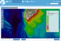
GeoData are responsible for all aspects of the National Coastal Monitoring Programme data management and open data web portal, including geospatial database and metadata search engine, web-based GIS i...
Posted 2025-05-29 08:40:39 by Admin
Heavy Axle Weight (HAW) Bridge Modelling

The GeoData team are collaborating with the University's Transportation Research Group on a major project funded by Network Rail and the Rail Safety and Standards Board (RSSB). The project investigat...
Posted 2025-05-29 09:05:32 by Admin
Southampton Science, Arts and Humanities Festivals

Southampton Science and Engineering Festival (SOTSEF) is the University of Southampton's annual award-winning interdisciplinary science festival that allows everyone to explore and discover what the w...
Posted 2025-05-23 12:42:51 by Admin
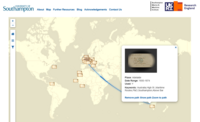
Atlas of Birth
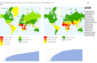
A tool to generate customised charts and maps illustrating maternal health around the world. The White Ribbon Alliance is an advocacy group for maternal health issues worldwide, lobbying for politica...
Posted 2025-05-23 12:01:05 by Admin
BRAgS - Building Resilient Agricultural Systems: sustainable livelihoods in Mega-Deltas under environmental change

BRAgS - Building Resilient Agricultural Systems: sustainable livelihoods in Mega-Deltas under environmental changeThe BRAGS GCRF project establish a new international and multidisciplinary collaborati...
Posted 2025-05-27 10:39:47 by Admin
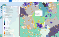
Health Literacy
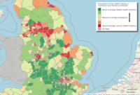
The Health Literacy tool, developed by the University of Southampton in collaboration with NHS England, offers interactive maps and data visualizations to estimate the prevalence of low health literac...
Posted 2025-05-27 10:45:57 by Admin
FruitSense

The FruitSense project is a UK-Australia collaboration aimed at enhancing the monitoring and management of Australia's tree crops through Earth Observation (EO) data and cloud computing technologies. ...
Posted 2025-05-27 10:47:49 by Admin
Peter Cook Postcards
The Peter Cook Postcards project provides digital access to a collection of postcards from the Hartley Library at the University of Southampton. Around 100 postcards depicting Southampton's history as...
Posted 2025-05-27 10:49:50 by Admin
Medieval French Roads
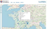
The Medieval French Roads Project offers a digital, interactive map showcasing roads and bridges in France from the 11th to the 16th centuries. This resource is built upon primary sources such as hist...
Posted 2025-05-27 10:51:30 by Admin
Active Travel Network (RATIN)
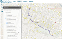
The Routable Active Travel Infrastructure Networks (RATIN) responds to the Active Travel Agenda that encourages and develops the data infrastructure to support walking and cycling for multiple transpo...
Posted 2025-05-27 10:53:38 by Admin
NHS Wellbeing

The NHS Wellbeing project is a collaborative initiative between the University of Southampton and key project partners in Hampshire including Portsmouth Hospitals University NHS Trust and Portsmouth C...
Posted 2025-05-27 10:55:33 by Admin
NASH SCOWT
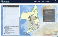
SCOWT (Shipping Constraints Online Web Tool) is an innovative platform developed by NASH Maritime to assist offshore wind developers in identifying and mitigating navigation and shipping constraints d...
Posted 2025-05-27 10:57:07 by Admin
Legal Aid Mapping
The Legal Aid Mapping project, led by the University of Sussex, investigates disparities in access to social welfare and legal aid more generally across the UK. Using a multilayered geographical and s...
Posted 2025-05-27 10:59:01 by Admin
CITISCAPE
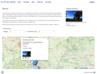
CITISCAPE is a citizen science research initiative developed by the University of Southampton in collaboration with Southampton City Council, aiming to understand and address the needs of young adults...
Posted 2025-05-29 08:27:09 by Admin
Maritime Britain
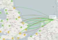
GeoData have collaborated with colleagues in the University's department of History on a number of projects exploring Medieval and Tudor Shipping, funded by the Arts and Humanities Research (AHRC), Le...
Posted 2025-05-29 08:13:55 by Admin
The Norman Rolls of Henry V
The Norman Rolls of Henry V (The National Archives C 64/8-17) are enrolments concerning King Henry's conquest and rule of Normandy between 1417 and 1422. Professor Anne Curry has for many years been ...
Posted 2025-05-29 08:06:41 by Admin
The People of 1381 (Peasants' Revolt)

The GeoData team led the data management, analysis and web development on an innovative research project producing the most comprehensive interpretation of the Peasants' Revolt to date. The revolt was...
Posted 2025-06-04 11:07:50 by Admin
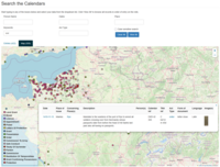
Online Data Management Systems for UK Government
The GeoData team have worked closely with UK Government clients, over a period of many years, in the development, delivery and support of complex online data management systems. Our Casework Tracker...


