
- GeoData
- » Web
| Date: | 2015 |
|---|---|
| Project: | uc1423 |
| Client: | NERC, RSSB |
| Value: | £45k |
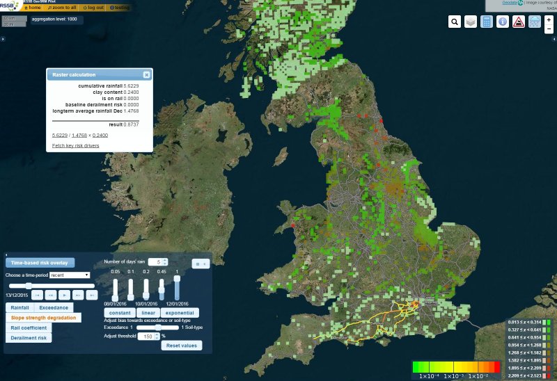
A tool to improve prediction of real time environmental risk to UK rail infrastructure
GeoData worked on the GeoSRM pilot to analyse and map risk across the GB rail network, initially in the Wessex region. This area of research was extended to incorporate the impact of real time environmental data on rail risk.
Research and development was carried out in collaboration with the Rail Safety and Standards Board and other academic and industry partners on the GeoSRM pilot project to analyse and map derailments, suicides and slips/trips/falls risk across the GB rail network, initially in the Wessex region.
A NERC 'Probability, Uncertainty and Risk in the Environment' (PURE) research grant was awarded to investigate this potential further and to extend the GeoSRM pilot to develop a tool which demonstrates the application of open environmental data to the improvement of risk modelling for the GB rail network.
The result was a scientifically robust methodology and an online interactive decision support system for identification of rail risk hotspots. This has established a way to flag certain locations for their near-real time vulnerability to environmental factors, with potential to contribute to further improvements in rail safety across Great Britain.