Stories tagged with "mapping"
Posted 2025-06-06 10:15:27 by Duncan Hornby
New Forest streams
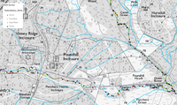
GeoData has a long history in running repeat surveys on capturing and analysing woody debris in selected New Forest streams. Originally data was captured on paper maps, but as technology improved, Geo...
Posted 2025-06-04 11:25:56 by Julia
Oak Processionary Moth project support
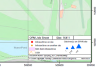
GeoData has supported the FC Plant Health team monitor and manage data about sites infested with, or suspected to be infested with, OPM, including: Development of MS Access databases for infested and ...
Posted 2025-05-27 10:49:50 by Admin
Medieval French Roads
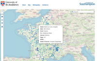
The Medieval French Roads Project offers a digital, interactive map showcasing roads and bridges in France from the 11th to the 16th centuries. This resource is built upon primary sources such as hist...
Posted 2025-05-27 10:47:49 by Admin
Peter Cook Postcards
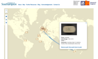
The Peter Cook Postcards project provides digital access to a collection of postcards from the Hartley Library at the University of Southampton. Around 100 postcards depicting Southampton's history as...
Posted 2025-05-23 12:46:46 by Admin
National Coastal Monitoring Programme
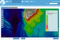
GeoData are responsible for all aspects of the National Coastal Monitoring Programme data management and open data web portal, including geospatial database and metadata search engine, web-based GIS i...
Posted 2025-05-23 11:25:25 by Admin
Tranquillity Mapping for Urban Greenspace Access and Healthier Journeys
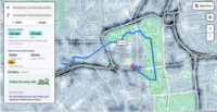
This HEIF-funded collaboration between Tranquil City Ltd and the University of Southampton’s GeoData Institute aims to develop a tranquillity index for the entire city. The project combines satellit...
Posted 2025-05-23 11:19:59 by Admin
Validating the Tranquil City Index (HEIF 2025)

This HEIF-funded project evaluates the Tranquil City Index (TCI) as a planning-relevant indicator of urban tranquillity by comparing it with psychological responses using the Perceived Restorativeness...


